CHAPTER 7 - Implementation 3
Objectives![]()
![]()
- Survey Line Drawing Algorithms
- DDA
- Bresenham
Rasterization
- Rasterization (scan conversion)
- Shade pixels that are inside object specified by a set
of vertices
- Line segments
- Polygons: scan conversion = fill
- Shade pixels that are inside object specified by a set
of vertices
- Shades determined by color, texture, shading model
- Here we study algorithms for determining the correct pixels starting with the vertices
Scan Conversion of Line Segments
- Start with line segment in window coordinates with integer values for endpoints
- Assume implementation has a write_pixel function
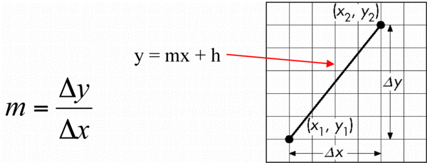
DDA Algorithm (Digital Differential Analyzer)
- DDA was a mechanical device for numerical solution of differential equations
- Line y = mx+ h satisfies differential equation
- dy/dx = m =
 y/x = (y2-y1)/(x2-x1)
- dy/dx = m =
- Along scan line x = 1
for(x = x1; x <= x2; x++) {

                y+=m;

                write_pixel(x, round(y), line_color)

                }
Problem
- DDA = for each x plot pixel at closest y
- Problems for steep lines
Using Symmetry
- For m > 1, swap role of x and y
- For each y, plot closest x
Bresenham's Algorithm
- DDA requires one floating point addition per step
- We can eliminate all fp through Bresenham's algorithm
- Consider only 0 <= m <= 1
- Other cases by symmetry
- Assume pixel centers are at half integers
- If we start at a pixel that has been written, there are only two candidates for the next pixel to be written into the frame buffer
Candidate Pixels
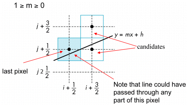
Decision Variable
Incremental Form
- More efficient if we look at dk, the value of the decision variable at x = k + 1/2

- For each x, we need do only an integer addition and a test
- Single instruction on graphics chips
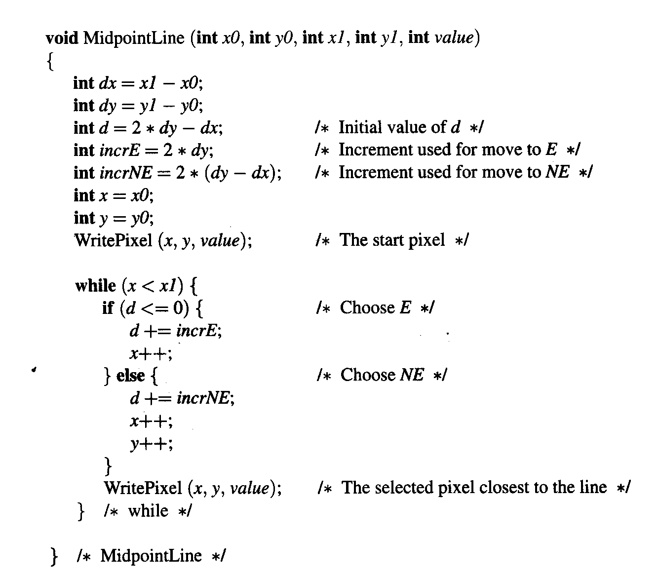
Midpoint Line Algorithm (alternate discussion from Foley)
Bresenham [BRES65] developed this classic algorithm which uses integer arithmetic and thus removes the need for the round operation. It can also be applied to the integer computation of circles. The algorithm can be extended to handle lines with fp endpoints.
The algorithm assumes slopes are in [0,1] and the lower left endpoint is at (x0,y0) and the upper right endpoint is at (x1,y1).
Using the grid below for discussion.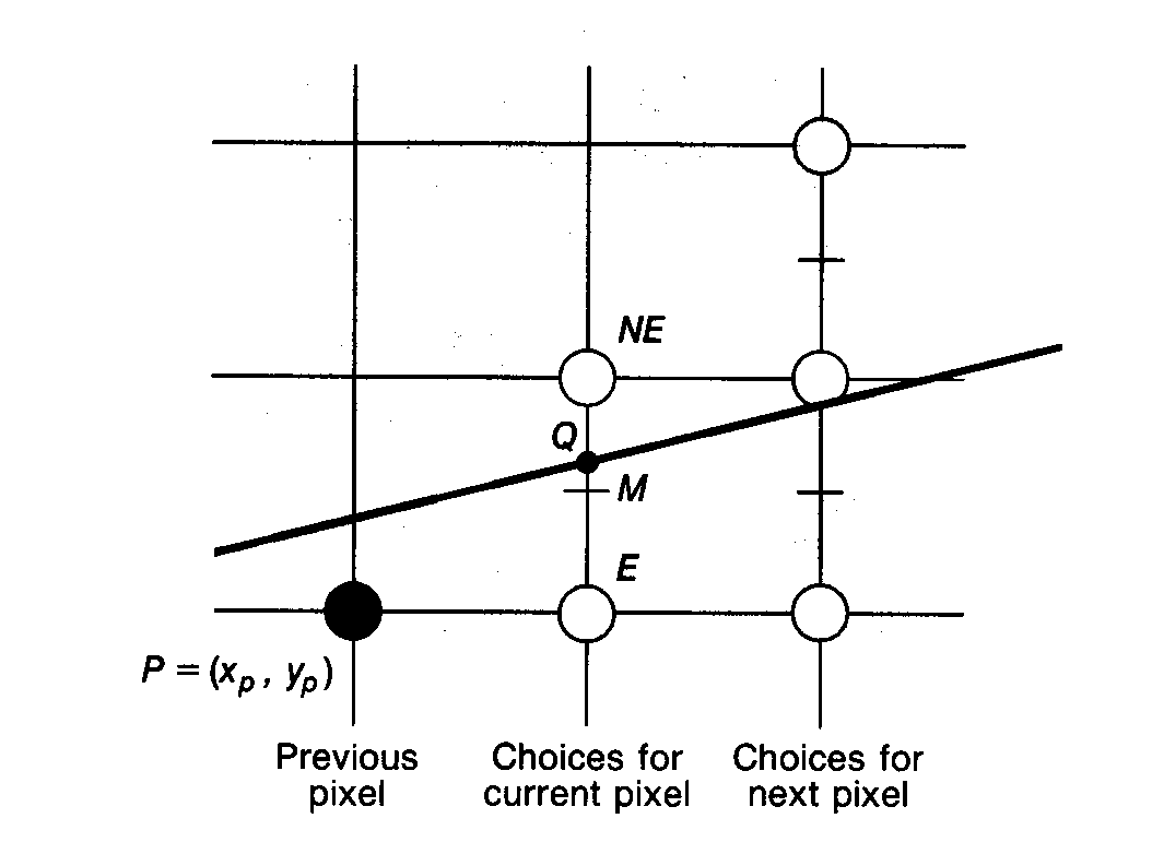
Assume pixel (xp,yp) has been selected to be displayed. Let point Q represent the intersection of the line we wish to draw with the line representing the vertical raster grid one pixel to the right of (xp,yp). We now have a choice, either select the pixel one increment to the right (pixel E) or select the pixel one increment to the right and one increment up (pixel NE).
Bresenham's algorithm computes the vertical distances from E to Q and from NE to Q. The sign of the difference is used to select the point whose distance from Q is smaller. This distance is always <= 1/2.
Algorithm :
- Using the line function, (x,y) = ax + by + c = 0
- and y = (dy/dx)x + B then (by subtr. y from both sides/mult. by dx)
- F(x,y) = dy(x) - dx(y) + dx(B) = 0 where
- a = dy, b = -dx, c = dx(B)
- For points on the line F(x,y) = 0, F is positive for points below the line and negative for points above the line.
EXAMPLE
Consider the line defined by endpoints (1, 2) and (5, 3). Then dy = 3 - 2 = 1, dx = 5 - 1 = 4 and B is determined as y = (dy/dx)x + B or
2 = (1/4) 1 + B, where B = 7/4.
The point (2,1) is below the line and F(2,1) = (1) 2 - (4) 1 + (4)(7/4) = 5.
The point (2,4) is above the line and F(2,4) = (1) 2 - (4) 4 + (4) (7/4) = -7.
END EXAMPLE
- To apply the midpoint criteria (assuming current point is (xp,yp)) we need to compute F(xp+1, yp+1/2) and test its sign. F at this point will be called the decision variable d = F(xp+1, yp+1/2).
- By definition d = a(xp + 1) + b(yp + 1/2) + c.
- if d > 0 then choose E point, if d < 0 then choose NE point, if d = 0 choose either, so pick E point.
- Next we must determine the amount to increment which depends
on the point chosen. If E is chosen then
dnew = F(xp+2,yp+1/2) = a(xp+2) + b(yp+1/2) + c
but
dold = a(xp+1) + b(yp+1/2) + c
If we subtract dold from dnew we get dnew = dold+a. Thus the /\E = a = dy
If NE is chosen then we increment in both directions and
dnew = F(xp+2,yp+3/2) = a(xp+2) + b(yp+3/2) + c
If we subtract dold from dnew we get dnew = dold+a+b. Thus the /\NE = a + b = dy - dx
To summarize: at each step choose between two pixels based on sign of decision variable d calculated in previous step. Update decision variable by /\E or /\NE depending on which point is chosen in current step.
To calculate the initial value of d to start the algorithm use the first endpoint (x0,y0) then
- The first midpoint is at (x0+1, y0+1/2) and
F(x0+1,y0+1/2) = a(x0+1) +b(y0+1/2) + c
= ax0 + by0 + c + a + b/2
= F(x0,y0) + a + b/2 and since F(x0,y0) is a point on the line it = 0.
- Thus dstart = a + b/2 = dy - dx/2
- To get rid of the fraction redefine F(x,y) = 2(ax +by+c)which does not affect the sign of the decision variable which is all that is needed for the algorithm.
Polygon Scan Conversion
- Scan Conversion = Fill

- How to tell inside from outside
- Convex easy
- Nonsimple difficult
- Odd even test
- Count edge crossings
- Winding number
Winding Number
- Count clockwise encirclements of point
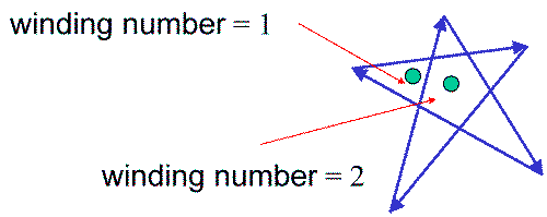
- Alternate definition of inside: inside if winding number != 0
Filling in the Frame Buffer
- Fill at end of pipeline
- Convex Polygons only
- Nonconvex polygons assumed to have been tessellated
- Shades (colors) have been computed for vertices (Gouraud shading)
- Combine with z-buffer algorithm
- March across scan lines interpolating shades
- Incremental work small
Using Interpolation
- C1 C2 C3 specified by glColor or by vertex shading
- C4 determined by interpolating between C1 and C2
- C5 determined by interpolating between C2 and C3
- interpolate between C4 and C5 along span

Flood Fill
- Fill can be done recursively if we know a seed point located inside (WHITE)
- Scan convert edges into buffer in edge/inside color (BLACK)
flood_fill(int x, int y) {
                      if(read_pixel(x,y)= = WHITE) {

                      write_pixel(x,y,BLACK);

                      flood_fill(x-1, y);

                      flood_fill(x+1, y);

                      flood_fill(x, y+1);

                      flood_fill(x, y-1);

                      } }
Scan Line Fill
- Can also fill by maintaining a data structure of all
intersections of polygons with scan lines
- Sort by scan line
- Fill each span
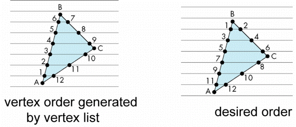
Data Structure

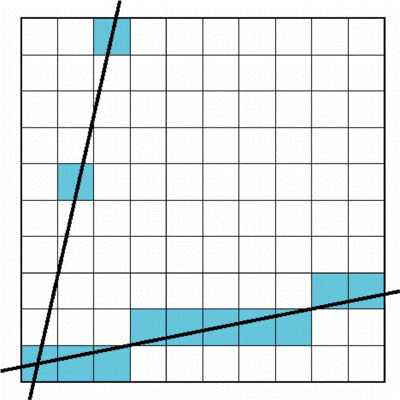
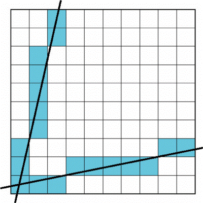
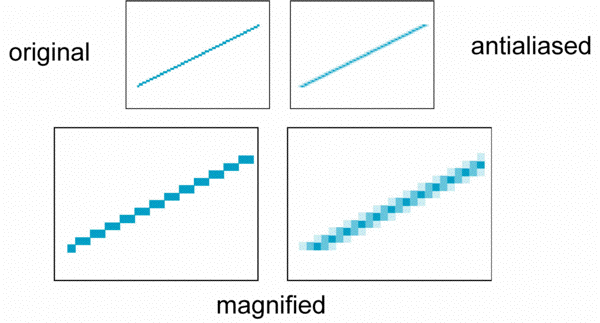
Aliasing
- Ideal rasterized line should be 1 pixel wide

- Choosing best y for each x (or visa versa) produces aliased raster lines
Antialiasing by Area Averaging
- Color multiple pixels for each x depending on coverage by ideal line
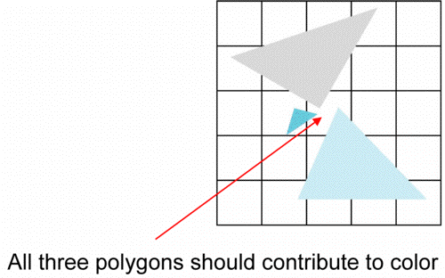
Polygon Aliasing
- Aliasing problems can be serious for polygons
- Jaggedness of edges
- Small polygons neglected
- Need compositing so color of one polygon does not totally determine color of pixel
![]()
![]()